Ngāi Tahu – Cultural Mapping Project

A food gathering highway

Waitaki

The Waitaki River was a principal ara tawhito (traditional travel route) for Kāi Tahu (Ngāi Tahu), providing direct access to the interior of Te Waipounamu. Over generations of occupation and use, Kāi Tahu developed extensive knowledge of the Waitaki, and the numerous kāika nohoaka (seasonal settlements) and kāika mahika kai (food-gathering sites) along the length of the river. Te Manahuna (the Mackenzie Basin) was a key component of the Kāi Tahu mahika kai system, and was renowned for the abundance of weka and tuna (eel) in the area. Kāi Tahu hapū from across the eastern and southern seaboards of Te Waipounamu undertook seasonal mahika kai expeditions to Te Manahuna, over a variety of traditional travel routes. The Waitaki via Ōmakō (Lindis Pass) provided direct access to Central Otago, and then via Tioripātea (Haast Pass) to the rich pounamu resource of Te Tai Poutini (the West Coast).

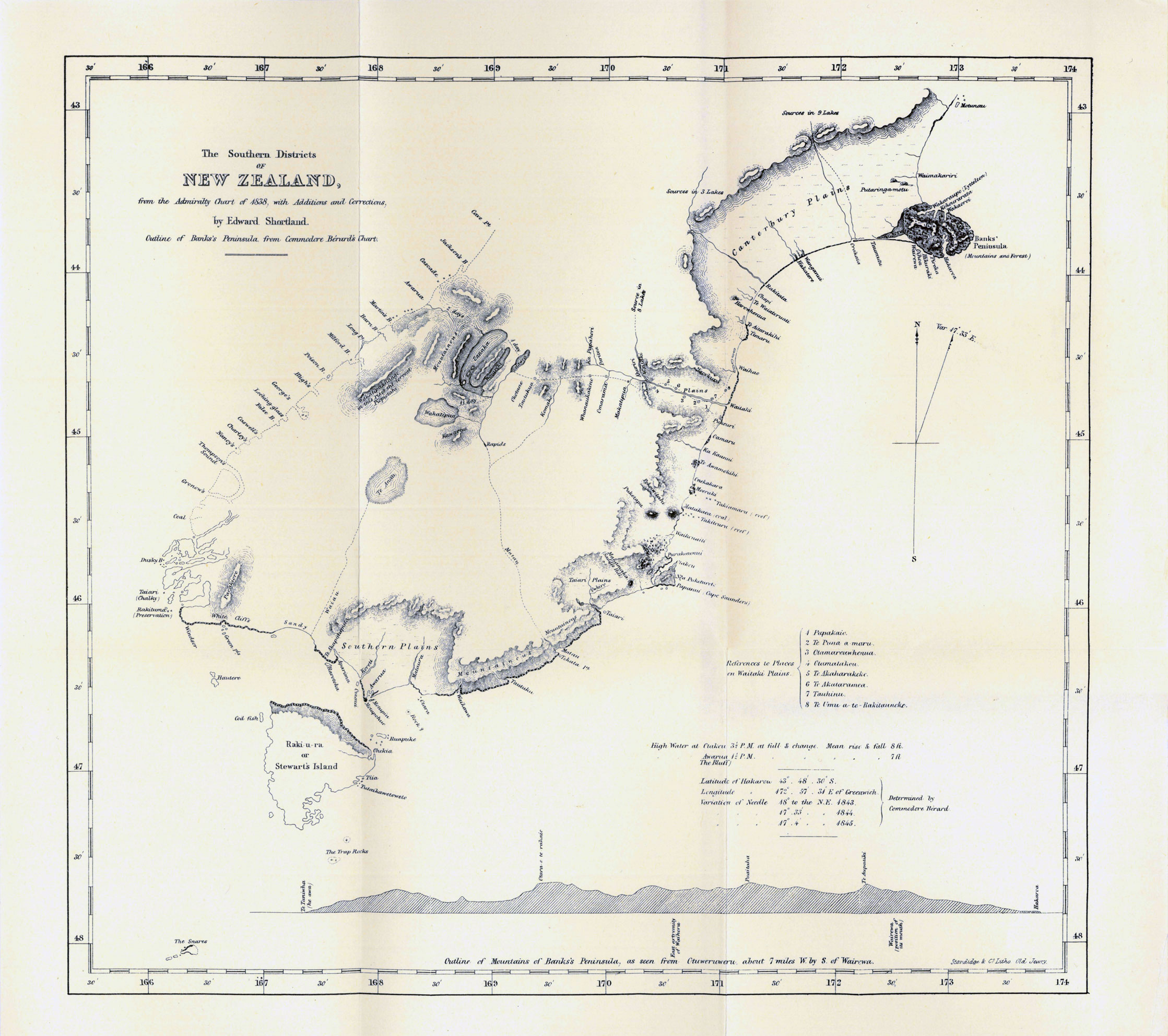
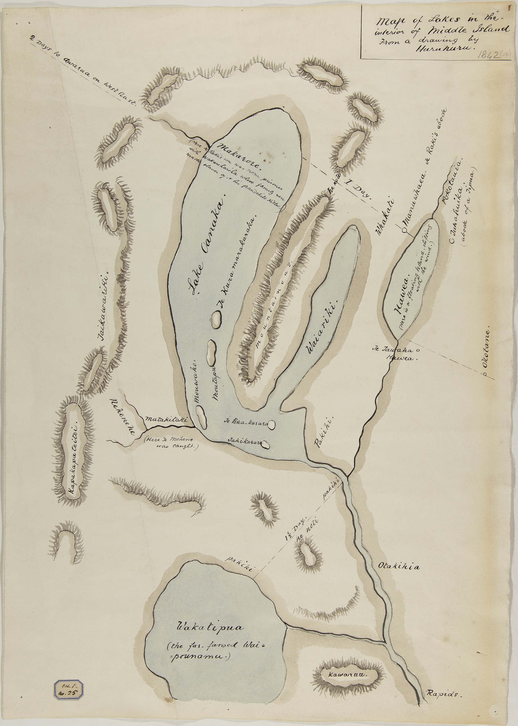
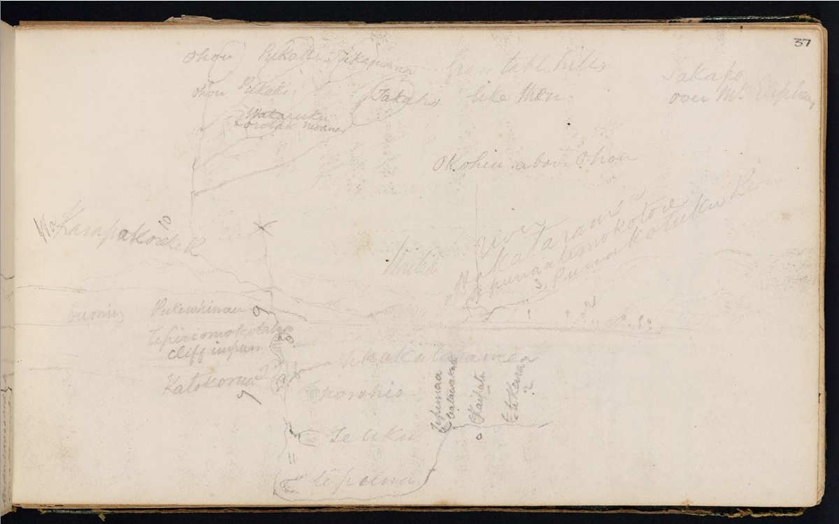
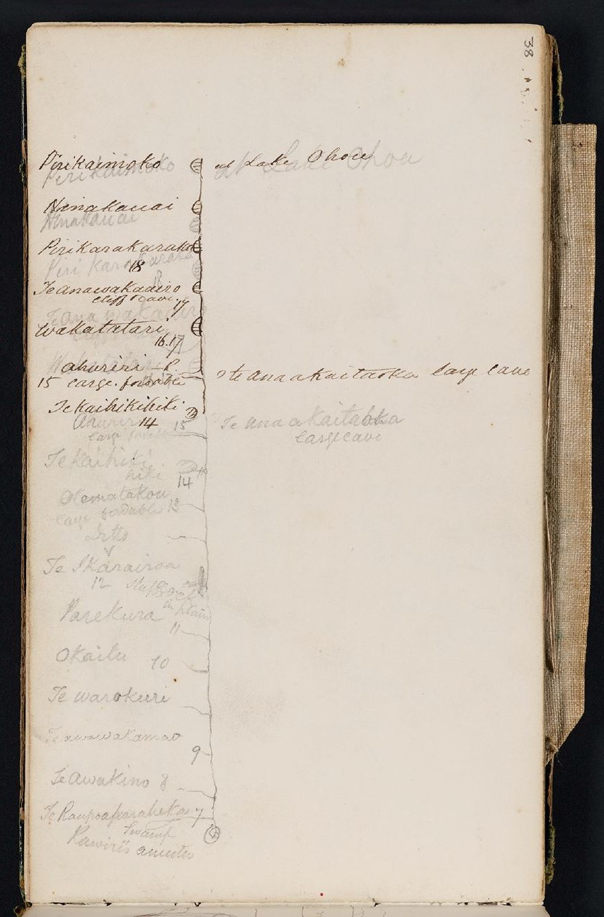
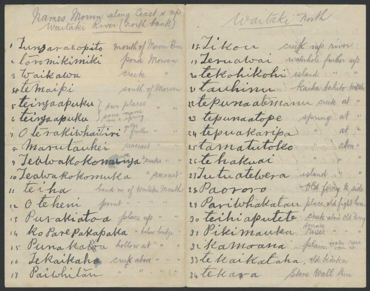
From the mouth of the Waitaki, people followed the awa (river) to where Lake Benmore now stands. They would either advance along the Ahuriri River and over Ōmakō (Lindis Pass) into the Central Otago region, or continue to follow the Upper Waitaki into Te Manahuna. Upon arriving at Te Manahuna, the Ōhau, Pūkaki and Takapō Rivers could be followed to their respective lakes and catchments.

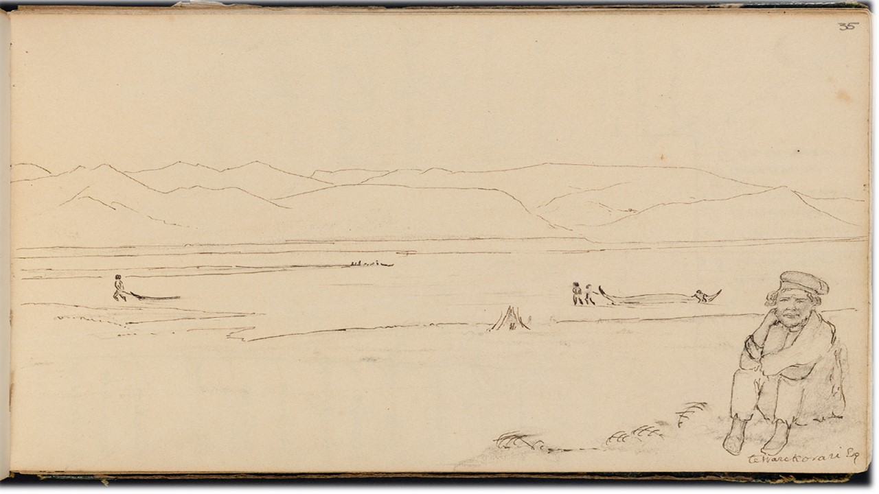
The traditional mode of transport on the Waitaki was mōkihi (raft-like vessels, constructed from raupō). Mōkihi enabled the resources gathered in the hinterland to be transported back to the coastal kāika with comparative ease. People walked up the Waitaki to gather mahika kai, and then used mōkihi to transport the resources back down the awa. Weka were gathered primarily during autumn and winter, when the fat content was at its highest, to be preserved for the colder months. The last recorded harvest of weka in Te Manahuna was in 1870, when three tonnes of birds were taken. Mōkihi were eventually replaced by horse and cart later in the nineteenth century. 

The creation of lakes Benmore and Aviemore in the 1960s, as part of the Waitaki hydroelectric power scheme, flooded parts of the old trail; submerging most of the known rock art sites in the Upper Waitaki Valley, as well as several traditional kāika mahika kai.

The Europeans will not allow [us] to kill the woodhens now, as it is said they are useful to kill the young rabbits. The tuis and all other birds are gone, and the roots of the kauru and the fern have been destroyed by fire. The Waitaki and all the other rivers have imported fish in them, consequently [we] are prevented from eeling or catching whitebait in season . . . in 1848 there was plenty of fish and other food, but after the land got settled the people gradually got hemmed in and prevented from obtaining the food that was available in former times.

Rāwiri Te Maire, 1891 Middle Island Native Land Claims Commission

“The Waitaki is a key fishery for Ngāti Māmoe, Waitaha and more recently Ngāi Tahu . . . I walked many of these makatea [trails] with my father when I was young, and they’re dotted with nohoanga [camp sites]. The hunting parties collected and processed food at these sites or stayed overnight on the way to food-gathering places.”

Kelly Davis

Te Huruhuru meets Edward Shortland in 1844


The southern Kāi Tahu leader Te Huruhuru was born around 1800. Although little is known of his whakapapa or life before 1844, his extensive knowledge of the interior suggests that he had previously resided in the Wānaka and Hāwea districts. By the mid-nineteenth century Te Huruhuru was a prominent Kāi Tahu leader in South Canterbury. He was considered the rakatira of the kāika of Te Puna-a-Maru that was situated on the southern bank of the lower Waitaki River, near its junction with Te Awamako.

When Edward Shortland arrived at Te Puna-a-Maru in 1844, while undertaking a census of the Māori population of southern New Zealand, Te Huruhuru agreed to ferry him across the flooded Waitaki. As he awaited the construction of mōkihi to carry the party across the river, Shortland obtained valuable information from Te Huruhuru about the geography of the interior of Te Waipounamu, including the first maps of lakes Wānaka, Hāwea and Whakatipu Waimāori (Wakatipu). Te Huruhuru also described inland settlements, trails and place names, and supplied the first recorded account of Te Pūoho’s raid. Shortland was grateful for the generous assistance and described Te Huruhuru as "a man of singularly pleasing manners and address".

The story of Edward Shortland’s travels down the Waitaki with Ngāi Tahu guides in 1844 was depicted in South Canterbury Saga, a film made by Folio Films in 1952 to commemorate the Timaru Centennial. The following film features Ngāi Tahu whānau members as the cast and was filmed on the Waitaki River.

There are no known photographs of Te Huruhuru. This image shows the waharoa at the entrance to the  urupā in Waimate where Te Huruhuru is buried. Te Rūnanga o Ngāi Tahu Collection, Ngāi Tahu Archive, 2017-0186-014.

Te Huruhuru 1844 Map

View video

This map drawn by Edward Shortland shows the information provided by Te Huruhuru on the place names and travel routes associated with the Waitaki River. 

This map of Wānaka, Hāwea and Whakatipu Waimāori (Wakatipu) is based on original pencil drawings by Te Huruhuru for Edward Shortland in 1844. In 1851 Shortland reproduced the map in his book The Southern Districts of New Zealand, and for many years the official Otago and Canterbury map showed the lakes as drawn by Te Huruhuru.

Te Wharekōrari guides Walter Mantell 1848


Following the signing of Kemp’s Deed in 1848, Walter Mantell, Commissioner for Extinguishing Native Claims, travelled from Kaiapoi to Dunedin to allocate native reserves within the recently purchased area.

When Mantell arrived at Te Puna-a-Maru in the spring of 1848, Te Huruhuru and most of his people were away at Waikouaiti. Not wishing to conduct the survey in the Waitaki chief’s absence, Mantell sent a message ahead, requesting that Te Huruhuru "return at once". Te Huruhuru was too ill with influenza to accompany the surveyors and sent Horomona Pōhio as his representative. 

After Mantell’s survey of the native reserve at Te Puna-a-Maru, Te Wharekōrari, who resided at Hakataramea, guided Mantell up the valley to Te Waikōura (incorrectly spelled today as Waikaura Creek) where Te Huruhuru requested a reserve for firewood. No reserve was ever established. Te Wharekōrari had an intimate knowledge of the Waitaki Valley, and drew Mantell six maps of the Waitaki River and the lakes of Te Manahuna, detailing many of the traditional Māori names located throughout the catchment.

Te Wharekōrari was one of the Ngāi Tahu guides who led Walter Mantell up the Waitaki Valley in 1848. This sketch drawn by Mantell shows Te Wharekōrari sitting on the southern bank of the Waitaki and mōkihi  in the river. E-333-035. Alexander Turnbull Library.

View the maps drawn by Te Wharekōrari

Te Wharekōrari Maps

View gallery

Tieke Pukurākau

Described as the last great mōkihi navigator of the Waitaki, Tieke Pukurākau (also known as Jack Pukurākau or Jack Pukuraki) spent most of his life living in the Waitaki region. Working at one time as a ferryman at the river mouth, Tieke was an expert at constructing mōkihi. Up until the early twentieth century, Tieke continued to make annual mahinga kai expeditions to Te Manahuna gathering birds and tuna (eels) to be preserved and stored for the upcoming winter months. 

Old Jack [Pukurākau] was a wizard at steering and could wriggle a course through roots, snags, trees, rocks or shingle beds that in the case of a less skilful steerer would have cut the flax underneath the raft and so ripped up its bottom so that it would break up. He used to take trips up to the heads of the lakes (Ohau, Pukaki and Tekapo) to get birds and more especially eels, to be preserved for storage as winter food. He had a pataka or whata down here to put his catch in and he valued his annual trips. The process was to gut the eels when caught and sun dry them or sun cure them and then pack them in handy form to be brought down river to the sea coast. Great numbers were caught and it required strong mōkihi to transport them. Sandy Te Maiharoa, speaking in the 1930s


Over years of occupation and use of the Waitaki, Tieke obtained an intimate knowledge of the place names throughout the catchment. In 1915 Tieke presented Pākehā historian James Herries Beattie with two long lists documenting the Māori place names along the Waitaki. The lists were written on "sheets of paper covered with his big, childlike handwriting". One list outlined the Māori place names situated along the northern bank of the Waitaki, and the second list the place names along the southern bank.

Tieke Pukurākau - the last great mōkihi navigator of the Waitaki - in a group photo taken in the Waitaki region during the early 1900s. Bill Dacker Collection, Toitū Otago Settlers Museum.

View the lists of Māori place names along the ara tawhito (traditional travel route) of the Waitaki River. These lists provide a detailed account of more than one hundred place names of creeks, islands, ponds, gullies, springs and many other landmarks located throughout the Waitaki Valley.

<p>Notebook of Māori place names along the north bank of the Waitaki River given to Herries Beattie by Tieke Pukurākau in 1915. MS-582/B/10.&nbsp;Hocken Library, University of Otago</p>

Tieke Pukurākau Notebooks

View gallery